
From Houston, I’ll be spending my next few days taking some scenic drives (actually, somewhere in the neighborhood of 400 miles of scenic drives…yikes!), visiting a few of the very cool nature preserves and, hopefully, dancing at a couple of dancehalls or honky-tonks, all in the Texas Hill Country. The Hill Country is generally…arguably…considered the prettiest region of Texas…outside of the Big Bend National Park region in the southwest. The Hill Country is beautiful, but in my limited experience, so far, I’ve found many areas of Texas quite beautiful for a variety of reasons. That said, I’ll be starting this portion of my trip at the eastern edge of the Hill Country, in San Marcos, which is south of Austin.
According to the website, texasthestateofwater.org, geologically-speaking, the area of the Hill Country is comprised of the 31,000 sq. mile Edwards Plateau, plus the 5,000 sq. mile Llano Uplift, which is located inside the Edwards Plateau. Other figures I’ve found, state that the area of the Hill Country ranges from somewhere between 8,100 sq. miles, to around 14,000 sq. miles.
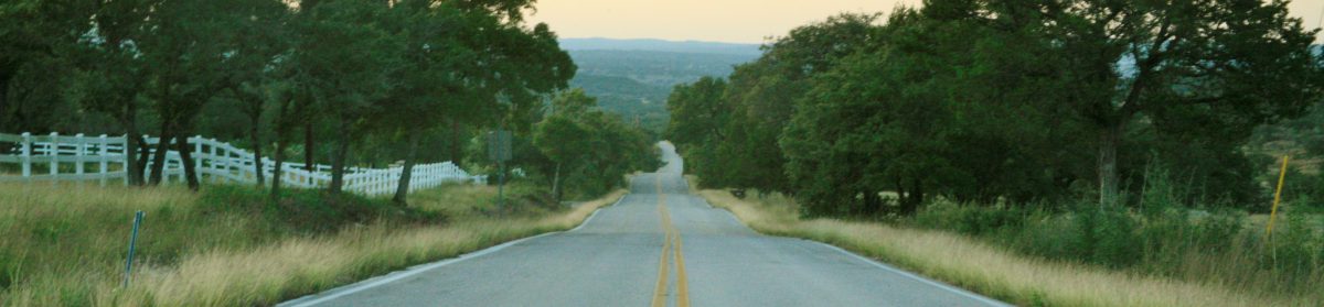
By comparison, Connecticut, my home state, is a mere 5,543 sq. miles in area…the entire state. Suffice it to say, the Hill Country is a big, open landscape, comprised of rolling hills crisscrossed with many streams and rivers. It’s pretty country, no matter how you look at it.
This leg of my trip is a happy accident that evolved out of a huge mistake on my part, early in my trip-planning. In my research, I stumbled onto a very long, detailed article online, in Texas Monthly Magazine, titled The Ultimate Hill Country Tour, which I didn’t realize until I was in too deep, had been published twenty years ago. Written by Joe Nick Patoski, a Hill Country resident, the article is a meticulous description of the author’s quintessential Hill Country scenic drives, along with some favorite places…restaurants, shops, nature preserves…to stop along the way. After dipping my toe in the Hill Country on my last trip three years ago…Hamilton Pool Preserve…The Salt Lick BBQ…Luckenbach…I was hooked and wanted to see more.
The author did not provide a map, so I made the crazy decision to comb through every detail of the article…scribbling notes in the margins…highlighting passages…piecing clues together…and eventually…after days of intense scrutiny…pretty much figured out every state highway, byway and back-road he had described, mapping it all out in Google Maps.
Mr. Patoski drove this route in four days, which is how I have it laid out, with a couple/few deviations. I’m hoping I’m allowing enough time. It’s a lot of curvy, hilly, back-road driving with nicknames and road-names, like “Devil’s Backbone” and “Willow Loop”, plus stops for some scenic hikes. And I hope I have enough energy after driving and hiking all day, to enjoy some dancing, out at a couple of cool dancehalls. Google Maps claims my driving times are reasonable. But, we shall see.
If you look at a map of central Texas, and begin literally or visually drawing an irregular, counter-clockwise loop (maybe a lasso would be more appropriate)…connecting the dots…starting from Austin…north to Lampasas…further north to Meridian…west to Comanche…southwest down to Brady…further southwest down to Junction…due-south to Uvalde…east to San Antonio…and back north, returning to Austin…you will have generally outlined the area known as the Hill Country. This is not my route. My route falls inside this rough perimeter and is considerably more irregular…more like the beginnings of a child’s Spirograph drawing.
Here’s a link to this cool Cartoon Map of the Hill Country (click on the 4-arrows icon at bottom-right of image to enlarge) that I came across in my trip-planning. If you look closely, a little northeast of Johnson City in pale letters, you’ll see Pedernales Falls State Park. This will be one of my nature stops. North of Johnson City, you’ll see Enchanted Rock State Natural Area, a pink granite dome rising 425 feet above the surrounding landscape, the second largest granite dome in the U.S., which is known to be a very cool spot for hiking…another planned stop.
And in the southwest area, north of Vanderpool, you’ll see Lost Maples State Natural Area, which is another hiking area and planned stop, that’s known for being the best place to view fall foliage in Texas, during the last two weeks in October and the first two weeks of November, depending on the weather. From what I’ve read, there is limited parking at Lost Maples, and the park and main road can get very crowded during the peak season, especially on weekends (which is when my schedule brings me there), so I may be setting myself up for disappointment. I’ll just have to wing it.
I’ll be staying in the Hill Country for three nights, two of which I’ll be staying in a guest cabin on a working Longhorn cattle ranch in Bandera, the “Cowboy Capital” of Texas. I also hope to be able to go on a horseback trail-ride on another ranch in Bandera.
My point is, there is a lot to see and do in the Hill Country, and you can really only get to a few things at a time. Also, you might think I’m crazy, devoting all of this time to scenic drives…and you may be right…because, among many other attractions, the Hill Country boasts an extensive wine-trail, with over fifty wineries, and I’ll be lucky to have time to stop at even one on this trip. But, aren’t wine-trails best enjoyed with company? So, since I’m ridin’ solo, I’ll save the wine-trail for another time.
I’m explaining all of this in advance, partly because the Hill Country is just that…hilly. And partly because, despite how crowded the cartoon map makes it look, the Hill Country is also mostly very rural, open countryside, so my internet…as well as my GPS…may be spotty. I don’t want my family or friends to be concerned if I don’t surface for a few days. I’m sure I’ll be fine, and will just be having a blast, getting myself lost in the Texas countryside.
I’ll be spending a couple of days in Austin on my way out of the Hill country, so hopefully, I’ll have some time to catch up a bit there, if I’m behind. As always…best laid plans. I really don’t know how any of this will work out. All I can do is plan and go.

Wow Phil, the hill country looks beautiful. I can’t wait to see a slide show of your travels! Enjoy this beautiful landscape. Thanks also for the travel guide. I might use it for future trips!
LikeLike
Tks, Teri! It is! But, I’m finding that it’s difficult to capture the feel of driving through the landscape in photos. It’s much better to actually visit here… drive on these hilly and curvy roads, and stop at the parks, nature preserves, bars, dance halls and restaurants yourself. I’m trying my best, though.
Oh! Wi-Fi and GPS (off the main roads) is very spotty here. I’ve lost it a couple of times, including at the B&B where I am tonight.
I haven’t been able to post. But, your comment came through.
LikeLike